Premier Listings for Sunshine Coast
The Sunshine Coast lives up to its name. With an annual total of between 1,400 and 2,400 hours of sunshine – that’s an average of 4 to 6 hours per day, depending on where the measurements are taken – bright days outnumber gloomy ones by a wide margin.
The Sunshine Coast benefits from a rain shadow cast by the Vancouver Island mountains, which catch most of the moisture coming in off the Pacific Ocean.
In winter, clouds regroup in the Coast Mountains to the east of the Sunshine Coast and provide sufficient precipitation in the form of snow to coat trails for cross-country skiing. The remainder of the year it falls as rain, British Columbia’s ‘liquid sunshine,’ which nourishes the temperate rain forest.
The Sunshine Coast is split into two portions on either side of Jervis Inlet. Roughly speaking, the southern half between the ferry slips at Langdale and Earls Cove occupies the Sechelt Peninsula, while the northern half between the ferry slip at Saltery Bay and Lund sits on the Malaspina Peninsula.
[FAGP id=26663]
The beautiful coastline is deeply indented at Howe Sound, Jervis Inlet, and Desolation Sound. Jervis becomes Queens Reach, slicing into the Coast Mountain Range, with a branch to Princess Louisa Inlet and Chatterbox Falls.
Jervis Inlet and Desolation Sound are of such fjordic proportions that they attract a steady stream of marine traffic throughout the summer months, when brilliant sun shines on the countless cataracts that cascade down the sheer-sided slopes. Come moodier months, the clouds become ensnared in the snaggle-toothed peaks, making you feel just as pleased to stick to the sunnier coastline.
The world’s longest highway, the Pan-American (also named Highway 101 in parts of the United States and Canada), stretches 9,312 miles (15020 km) from Castro on Chile’s south coast to Lund on BC’s Sunshine Coast.
The 87-mile (139-km) stretch of Highway 101 between Langdale and Lund outperforms its size. Dozens of parks with biking, hiking, and ski trails; canoe and kayak routes; beaches; and coastal viewpoints are easily reached from the highway. Campsites are plentiful, and you won’t have any difficulty in finding a place to pitch your tent or park your RV, except in July and August and on long weekends from May to September.
Population: Approximately 60,000
Location: The Sunshine Coast located northwest of Vancouver and is accessible from the rest of the Lower Mainland only by boat or airplane. Travellers aboard BC Ferries leave Horseshoe Bay in West Vancouver for a 9.5-mile (15.5-km), 45-minute ride to Langdale on the Sechelt Peninsula. Highway 101 links Langdale with Earls Cove, 50 miles (80 km) north. Another ferry crosses Jervis Inlet to Saltery Bay, a 60-minute ride. Highway 101 makes the second leg of this journey 37 miles (59 km) north to Lund. BC Ferries also connects Powell River on the Malaspina Peninsula with Comox on the east side of central Vancouver Island.
Vehicle and Passenger Ferry Routes to the Sunshine Coast:
- Horseshoe Bay Ferry Terminal
- Langdale Ferry Terminal
- Earls Cove/Saltery Bay Ferry Route
- Powell River/Comox Ferry Route
A note about travel times: One of the most enjoyable aspects of visiting the northern Sunshine Coast in the off-season from September to May – particularly if you travel midweek – is being able to catch the ferry both from Horseshoe Bay to Langdale, and then from Earls Cove to Saltery Bay, without experiencing interminable lineups. You’ll still have to allow six hours to reach the Malaspina Peninsula from Horseshoe Bay, but you can do it without hurrying, enjoying the travel time just as much as the play time once you arrive. If you can’t travel midweek to avoid lines, at least leave Vancouver early Friday afternoon or late Saturday morning and return early on Monday. Those travelling up the entire coast or returning via Vancouver Island should ask at the Horseshoe Bay terminal about special fares (which can save you up to 30 percent) for the Circle Tour of Vancouver Island and the Sunshine Coast (four ferry rides).
Circle Tour: See the best of the area on a driving Circle Tour. Head north out of Vancouver for the scenic Sunshine Coast and Vancouver Island Circle Tour. Board a B.C. Ferries vessel at Powell River that will take you across the waters of the Strait of Georgia to Comox, on Vancouver Island’s east coast. Travel south to Victoria and return to Vancouver by ferry from Swartz Bay to Tsawwassen.
View maps of the area
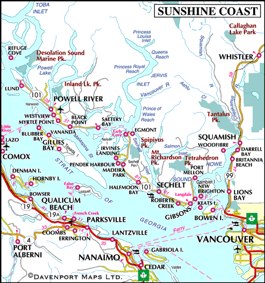
- Map of Sunshine Coast
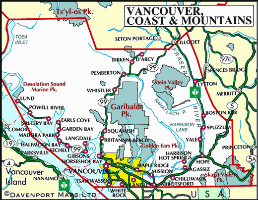
- Map of Central Vancouver Island and Sunshine Coast
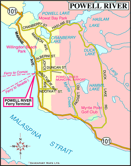
- Map of Powell River
The following communities are located on the Sunshine Coast, listed in a northbound direction:
Malaspina Peninsula
Coastal Inlets
To the north of the Sunshine Coast are fjord-like inlets that cut deep into the Coast Mountain Range, providing fabulous wilderness adventures and wildlife experiences:
Premier Listings
Rockwater Secret Cove Resort

Biographical Info
Rockwater Secret Cove Resort’s unique Sunshine Coast location provides a haven for seaside vacations, weddings or functions, and executive retreats with your colleagues to energize and refocus. Our romantic getaway offers ocean views from all lodge and cabin rooms, excellent conference and banquet facilities for up to 200 people, a fully-licensed cocktail bar and lounge, fine dining restaurant overlooking Georgia Strait, games room, outdoor heated pool, massage at Rockwater Spa, and much more. Stroll our forest boardwalk or relax on the wide lawns above our Secret Cove. Time slows down to almost nothing in our oceanfront haven.


