The exposed waters of Vancouver Island’s southwestern coast quickly dispel any notion than an ocean is an ocean is an ocean. The true personality of the Pacific is revealed as you traverse the slopes of San Juan Ridge as the Strait of Juan de Fuca makes its entrance from the open water of the Pacific. Conditions shift dramatically from the sheltered waterways of the Strait of Georgia, with its gaggle of tranquil islands. Here you face the open ocean, where nothing breaks the rolling swells or deflects the sting of winter storms.
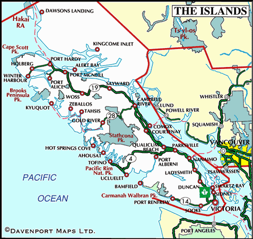
The Pacific Marine Circle Tour can be driven in a day, but with so many attractions along the way, the 255-km route is best enjoyed as a two to four-day trip. Commence this exciting route in Victoria, the provincial capital of British Columbia. Conde’ Naste Traveler Magazine reader’s poll rated Victoria one of the top ten cities to visit in the world. The picture-perfect Inner Harbour is surrounded by many of Victoria’s beautiful character buildings and premier attractions: the stately Empress Hotel, the provincial Legislative Buildings, museums and galleries.
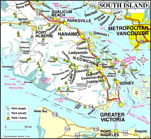
Head north via Highway 1, and then travel west along the West Coast Highway 14 to the community of Sooke. Sooke’s unspoiled beaches, meandering rainforest trails and breathtaking vistas of Washington State’s Olympic Mountains attract visitors from around the world, eager to catch a glimpse of Vancouver Island’s rugged west coast.
Sooke is the gateway to the scenic West Coast Road, which winds 74 km along the coast to Port Renfrew, and the starting points for the world-famous West Coast Trail and Juan de Fuca Marine Trail. This is one of South Vancouver Island’s most spectacular drives; it winds through coastal rain forest and along the jagged coastline, passed bed and breakfasts and seaside cafes, leading to some amazing beaches found nowhere else on the coast, with views that engender intimacy with the landscape, yet emphasize its isolation. En route is French Beach Provincial Park, the community of Jordan River, and Juan de Fuca Provincial Park (China Beach, Sombrio Beach, and Botanical Beach).
Port Renfrew calls itself the Jewel of the West Coast, where you can experience the tranquility and beauty that has made the West Coast famous. Take a leisurely 15 to 20-minute easy walk to Botanical Beach in Juan de Fuca Provincial Park, and discover fascinating tidal pools rich in marine life, one of the best opportunities to view intertidal marine creatures and plants on Vancouver Island. Botanical Beach is one of the most amazing places on the entire West Coast, with tide pools filled like jewel boxes with brightly coloured marine animals. Humpback whales can often be observed feeding mere metres from the rocks.
Depart Port Renfrew on the unpaved Harris Creek Main logging road, which is in good condition and well graded although it is still used by logging trucks – one of the reasons it is well maintained. Keep your eyes peeled for bears and elk in the wilderness around Port Renfrew, as these wild animals can be encountered anywhere in the region.
A pleasant place to stop for a picnic or swim is Lizard Lake, 18 km northeast of Port Renfrew on the Harris Creek Main logging road. Lizard Lake is filled with newts (salamanders), hence the origin of its name. Sit quietly on the swimming dock, and you may see the salamanders swimming up to the surface before disappearing into the depths again. Nearby Fairy Lake, however, is not filled with fairies!
Well worth a stop is the giant Harris Creek Spruce, a tree so big that it would take 15 people to form a human chain around the trunk. The incredible tree is conveniently located right at the roadside, accessed via a small, wooden footbridge.
The legendary Red Creek Fir (73.8 metres high, 12.5 metres in circumference) is situated along the San Juan River, but requires a short hike and clear directions to locate it – don’t rely on markings on road maps to find it.
From Port Renfrew to the quiet shoreline communities of Mesachie Lake and Lake Cowichan in the Cowichan Valley the road is paved and family vehicles can do the trip. Drivers must exercise caution as this road is used by massive logging trucks that take up a good portion of the road, and drivers trying to avoid oncoming traffic can get caught in loose gravel on the side of the road. There are no services available along the route.
The town of Lake Cowichan is the gateway to some of the most spectacular camping and hiking available on Vancouver Island. Other communities such as Honeymoon Bay, Skutz Falls, and Youbou are within easy reach by road. All have access to scenic Cowichan Lake, one of the largest freshwater lakes on Vancouver Island. It won’t take long to notice that fishing is more than just a pastime here…it’s a passion and a way of life.
Travelling east on Highway 18 you reach the city of Duncan. You can’t really say you’ve experienced the heart of the Cowichan Region until you’ve made the decision to get out of your car and wander leisurely around downtown Duncan, savouring the city’s shops, restaurants, galleries, and First Nations’ cultural attractions. Take a ‘Totem Tour’ or visit the Quw’utsun’ Cultural & Conference Centre and experience authentic native cuisine, view Coast Salish arts and crafts, or take part in a live native show.
Duncan is home to the BC Forestry Discovery Centre, a museum with interactive logging exhibits, train tours, and antique logging equipment. Adjacent to the museum is the Somenos Marsh Wildlife Refuge and bird sanctuary, which can be viewed from a turnout on the island highway.
The Cowichan Valley region is the heart of Vancouver Island’s burgeoning wine country, a place where you can spend a few hours – or a day or two – sampling award-winning wine and cider, visiting a local cheese maker, and dining in a cozy orchard bistro.
Head south on Highway 1, branching off to the South Cowichan community of Cobble Hill. The Cowichan Valley is characterized by diverse and picturesque landscapes of forests, freshwater lakes, saltwater beaches, and marinas, farmland, and vineyards. Continue to the seaside community of Mill Bay. The surrounding parks and scenery are lovely – perfect for hiking, cycling and boating. This is an ideal spot to spend a few days, basking in the sun and swimming in warm waters.
You may want to stop at Bamberton Provincial Park, one of the more scenic locations on Saanich Inlet. Continue to Victoria on the Trans-Canada Highway 1, which takes you over the Malahat and scenic view points over Saanich Inlet, the Gulf Islands, and the snow-capped Mount Baker in Washington State on the mainland.
After crossing the Malahat, visit Goldstream Provincial Park before continuing south to Victoria. This is a showcase for provincial parks, and the natural beauty of the environment makes this a special place to explore at a leisurely pace. You can easily spend an hour strolling through the impressive old-growth rain forest that is home to 600-year old Douglas-fir trees and western red cedars. In late fall the shallow, clear river is alive with salmon struggling upstream to spawn, just metres away from you. Share the spectacle with raucous seagulls, American dippers, bald eagles and the occasional black bear feeding on spent salmon in the estuary.
An alternative to driving the Malahat is to board a BC Ferry from Mill Bay to Brentwood Bay on the Saanich Peninsula. This scenic 25-minute ride, dubbed Vancouver Island’s most Beautiful Shortcut, lets you complete your tour with a visit to the famous Butchart Gardens and Victoria Butterfly Gardens, before heading south on Highway 17 to Victoria.


