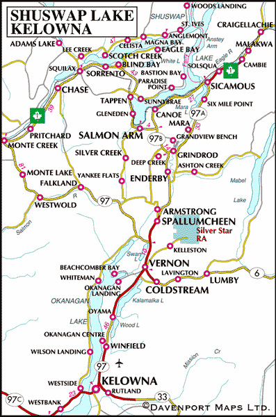
The small farming village of Grindrod is located on the west bank of the Shuswap River, north of Enderby in the North Okanagan. Set in peaceful and rural surroundings, Grindrod is full of country charm with a storybook setting; a popular destination with visitors.
Grindrod was named after Edmund Holden Grindrod, the first Canadian Pacific Railway inspector of telegraphs in British Columbia (1886), who later became a farmer near Kamloops. Grindrod was originally part of the Carlin Estates in North Enderby after James Carlin acquired 1,300 acres in this area in 1898. Carlin surveyed what was to become the Grindrod townsite in 1910.
Today, Grindrod’s main industry is agriculture, with spectacular scenery attracting many visitors to the peaceful area.
Population: 1,450
Location: The community of Grindrod is located on the west bank of the Shuswap River in the North Okanagan, south east of Salmon Arm and 8 miles (13 km) north of Enderby on Highway 97A.
Golf: Golfers can tee off at the Birchdale Golf Course, which offers a 9-hole course covering 1,257 yards of mostly level ground. The towering red-tinted lava face of the Enderby Cliffs on the east side of the valley make a spectacular setting for Birchdale Golf Course, located 19 miles (30 kms) north of Vernon on Highway 97A. Golf Vacations in British Columbia.
Larch Hills Cross-Country Area, north of Grindrod, has an impressive 87 miles (140 km) of cross-country skiing trails, about 25 miles (40 km) of which are groomed. To reach the trailhead, drive north on the road to Grandview Bench. Proceed north on Edgar Road for 1 mile (2 km). The club maintains a chalet, which is open to all, the site of the annual ‘loppet,’ or cross-country ski race.
Snowmobiling rules in nearby Enderby, home to the Hunters Range Snowmobile Association, which sponsors a number of annual snowmobiling events, including the popular Snowrama in February. This group operates a day chalet and shelter, and has marked groomed and non-groomed trails in the 200 square kilometres of great snowmobiling amongst the alpine meadows and bowls in the Hunters Range east of Enderby.
Hiking: Hikers can hike the Enderby Cliffs Trail (5 hours/10 km) and the Spring Falls Trail (2 hours/6km) east of Grindrod.
Mara Provincial Park is a small 5.9-hectare park situated on the eastern shores of Mara Lake north of Grindrod. The park is strictly a day-use area, but offers a variety of recreational activities. The park has a beautiful broad stretch of sandy beach and is popular for fishing, swimming, boating, canoeing and picnicking.
South of Grindrod is the town of Enderby , located south of Mara Lake on the banks of the Shuswap River. The idyllic riverfront community of Enderby is nestled below the steep volcanic Enderby cliffs, which tower high above the city. When viewed from Enderby, local legend has it that the ridge resembles the head of the Neanderthal Man who guarded the northern gateway to the Okanagan Trench in the days of yore.
Northeast of Grindrod on Highway 97A is the community of Mara, and the town of Sicamous, situated at the junction of the Shuswap and Mara Lakes in the Eagle Valley. The community of Sicamous is known as the Houseboat Capital of Canada, due to the more than three hundred houseboats that are rented out annually from the marinas on Shuswap Lake.
Northwest of Grindrod via Highway 97B is the town of Salmon Arm, in the heart of British Columbia’s famous Shuswap Lake recreation area. Nestled on the south shores of Shuswap Lake, Salmon Arm is the largest town in the Shuswap area.
Circle Tours: See the best of the area on Okanagan and Kootenay Rockies Circle Tour. Travel the sunny interior of British Columbia, north through the Okanagan to Sicamous, following Highway 1 into the mountains of the BC Rockies. From Golden, head south through the Columbia Valley to Creston, and west through the Southern Okanagan, starting and ending your sun-drenched voyage in Osoyoos, the place where two lakes come together. Circle Tours in British Columbia.


