Surrounded by desert to the south, and lakes, mountains, vineyards and orchards in almost every other direction, is the town of Oliver in the South Okanagan, once covered by cacti and sage brush.
The First Nations of the South Okanagan settled the area around Osoyoos and raised cattle and wild horses. The first encroachment from the outside world came in approximately 1811, when fur traders came searching for better trade routes.
In the 1880s, free gold-bearing quartz was found east of the present day Oliver, and Camp McKinney became a busy gold mine, attracting the usual restless characters: miners, con men, and outlaws.
Established between 1918 and 1921 as a settlement for unemployed veterans of the First World War, a gravity-fed canal was constructed to provide irrigation to the semi-arid area, which accounts for the lush greenery around this Capital of Wine Country, one of the most picturesque places in the Okanagan.
The founders of Oliver named the town after “Honest” John Oliver, a BC premier after the First World War, who believed that the irrigation canal would bring prosperity to this northern end of the Great Basin Desert. The Pocket Desert is part of the Great Basin Desert, part of the network of deserts that extend southward to the Sonoran Desert in Mexico.
Oliver was unincorporated for many years, and was run from Victoria, the provincial capital of British Columbia. The town was incorporated in 1946, and elected its own council in 1968.
Oliver has a climate that suits just about everyone, from California bighorn sheep to Northwestern Pacific Rattlesnakes. Whether splashed with the pink blossoms of spring or surrounded by the bursting colours of autumn, the orchards, forest, vineyards and mountains around Oliver are beautiful. Magnificent scenery can be reached within ten minutes from just about anywhere in Oliver, and afternoon drive possibilities are almost endless.
Oliver is an area full of fascinating features. Entering the town from the north, the impressive face of McIntyre Bluff, known as Indian Head, looms over the highway. There are legends alluding to rival Indian Bands being driven off the edge of the 250-metre high cliffs. Indian pictographs etched in the rocks are one example of this area’s incredible history.
Today, Oliver is a thriving community, with agriculture, tree fruits and vineyards still prime industries. The economy is still dependent upon the irrigation ditch to keep the land arable, although the ditch has seen many changes and upgrades over the years.
Population: 4,369
Location: Oliver is located on Highway 97 in the south Okanagan, 16 miles (26 km) north of the Canada/United States border, 27 miles (43 km) south of Penticton and 16 miles (26 km) north of Osoyoos.
Cherry Pie: The world’s largest cherry pie was baked here in 1990, which gives you some idea of how much fruit this region produces. Weighing in at almost 18,000 kg, this pie was huge! Yes, it did make it into the Guinness Book of World Records, and no, there isn’t any left!
The old CPR Station, built in 1923 to serve a branch line of the Kettle Valley Railway, has been restored and now houses the Oliver Visitor Centre. The Canadian Pacific Railway (CPR) leased the line in 1931, but with the advent of highway traffic the line became less useful, and the last train passed through Oliver in 1977. This is a must see attraction, along with the still used Town Hall, which was built in 1923.
Located in the former provincial Police Station, built in 1924 in California bungalow style, is the Oliver Heritage Museum. The museum displays the history and natural history of Oliver and the surrounding district. Features include historical photographs and documents, and the Fairview Jail, built in 1896 and moved from the Old Fairview town site to the museum grounds.
Walking Tour: Pick up a map from the Visitor Centre, and embark on the Oliver Heritage Walk through the town. Starting at the CPR Station and ending at the museum, this 25-minute self-guided tour allows you to experience some of Oliver’s past. Highlights include the CPR Station, the 1946 Oliver Theatre, the 1937 Oliver Chronicle Building, the 1912 Oliver Hotel, which was moved from New Westminster to its present location in 1921, and many other fascinating town landmarks.
Annual Festivals: Be sure to stop by for the annual Festival of the Grape and Lavender Festival held in October.
Wildlife: Oliver is a premier spot to catch a glimpse of California Bighorn Sheep, or to view some rare species such as the Burrowing Owl. It is also home to the Federal Migratory Bird Sanctuary, which serves as a resting place for most species of migratory birds in the area. British Columbia is one of the richest wildlife viewing areas in Canada.
For a bird’s-eye view of the lake and the Similkameen and Okanagan Valleys, follow the gravel road from Osoyoos to the summit of Mt. Kobau, one of the tallest peaks around. A great spot for stargazing and hiking, and the views are nothing short of spectacular.
A stargazer’s delight, the Dominion Radio Astrophysical Observatory keeps its telescopes pointed skyward. Tour the property on a self-guided tour, during daylight hours, and listen to informative recorded messages.
Okanagan Wineries: The South Okanagan is wine country, and Oliver is one of the first stops on the Okanagan wine tour, so try to arrange time to visit at least one of the fifteen local wineries for a tour or a taste of the best in Canadian wines. Browse through their wine shops, enjoy some of the best views of the valley, and see why Oliver wants to become known as The Wine Capital of Canada! The wine culture is found on scenic backroads and verdant hillsides where each winery makes a unique contribution to the rich and varied landscape.
Wineries in the Okanagan Valley
Desert In BC: Explore Canada’s desert! The South Okanagan of British Columbia is one of the most unique and endangered ecological regions in North America. It is Canada’s only “arid” desert environment, and is home to over 100 rare plants and over 300 rare invertebrates. The Desert Centre, located 9 km north of Osoyoos, is an interactive interpretive education and research facility, offering an insight into this sensitive ecosystem. The Pocket Desert Federal Ecological Reserve is found on Black Sage Road, which runs through the heart of the desert, parallel to Highway 97 for 14 kilometres, but at a slightly higher elevation. From the highway, turn onto Road 22. This area receives an average rainfall of less than 20 cm per year. Growth is sparse, and the desert plants and animals of this area are found nowhere else in Canada. The Pocket Desert is part of the Great Basin Desert, part of the network of deserts that extend southward to the Sonoran Desert in Mexico. In fact, the plants and animals here are the same as those found in the higher elevations of the Mexican portion of this desert. Typical plants found are sagebrush, greasewood, rabbit and antelope bush, and bunch grass. Some animals that may be spotted are yellow-bellied marmots, pygmy horned toads, painted turtles, various lizards, white throated swifts, nighthawks and Calliope Hummingbird. Watch for rattlesnakes. This area is also the site of an owl recovery program.
Inkaneep Provincial Park : Seek a cool riverside respite from the Okanagan sun at the Inkaneep Provincial Park, 6 km north of Oliver on Hwy 97. A trail provides access to the Okanagan River and some good spots for camping, fishing, and canoeing, but take binoculars; the area’s thickets are a well-known habitat for birds such as the black-headed grosbeak, American redstart, northern oriole, and many others. Some unique flora and fauna are present in the nearby ecological reserve.
For a special wildlife viewing experience, take a day visit to Vaseux Lake Provincial Park, about 20 km north of Oliver on Highway 97. Here, the Vaseux Lake Nature trust operates the Vaseaux Wildlife Centre, with a Canadian Wildlife Services wildlife sanctuary adjacent to the park ensuring protection of critical bighorn sheep winter range. The cliffs surrounding the park include spring and winter range of California bighorn sheep, and the area is famous for birdwatching. Grasses, reeds, willows and shrubs along the shore afford a home to many varieties of wildlife. Waterfowl, including trumpeter swans, widgeons, Canada geese, wood ducks, and blue-winged teal, are common. In spring, the beautiful lazuli bunting has been seen. Other bird species present include chukar partridge, wrens, swifts, sage thrashers, woodpeckers, curlews, and dippers. Mammal species found here include beavers, bats, cottontail rabbits, muskrats, deer and mice. Rattlesnakes, toads, and turtles live in this area. Considerable populations of largemouth bass, rainbow trout, and carp make their home in the water, and in winter, the frozen lake offers excellent conditions for ice fishing as well as other ice-related activities. Vaseux Lake is a mecca for paddler’s and naturalists.
Golf: Oliver offers two fine golf courses: Fairview Mountain Golf Club has established a reputation for distinctly spectacular golf. The semi-private championship course offers stunning views, 18 memorable holes (7,000 yards, par 72), and is rated #18 on Score Magazine’s list of top 100 golf courses in Canada. A must on any golfer’s tour of Desert Wine Country. Inkameep Canyon Desert Golf Course is the newest addition to the south Okanagan’s golfing experience, built amongst rows of cherry trees. Owned and operated by the Osoyoos Indian Band, the semi-private, 18-hole championship Nk’Mip golf course is situated on the south end of Tuc El Nuit Lake, a few minutes drive from downtown Oliver. Golf Vacations in British Columbia.
The International Bicycling and Hiking Society has developed a lovely little 20-km river ride between Oliver and Osoyoos along the scenic Okanagan River. To find this easygoing ride, just head east on any of the turnoffs from Highway 97 between McAlpine Bridge (the northern terminus of the trail) and Road 22. Cyclists will find the trail to be safer, faster and more scenic than the highway.
Hiking & Biking: Hikers and bikers can enjoy a number of trails in the area. One challenging route is the Golden Mile, a 10-km trail with the trailhead at the Tinhorn Creek Winery south of town, and for those who prefer mountain woodlands and secluded lakes for a backdrop, a trip to Sawmill, Madden and Ripley Lakes will suit your fancy. East of town, McKinney Road travels past several cross-country ski trails at the 1,450-metre level, which are just as interesting to traverse in the summer time.
Picnickers and frisbee-tossers will enjoy Rotary Beach on Tuc-el-Nuit Lake, and Kiwanis Park by the bridge on 350th Street is a quiet spot to relax and reflect. Or take the kids to the Kinsmens playground just west of the bridge and let them frolic.
Fishing: If fishing is your passion, a short drive north of town to Vaseux Lake will probably net you a rewarding catch of largemouth and smallmouth bass, rainbow trout or kokanee, while you are surrounded by a landscape of stone and serenity.
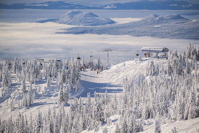
If you’re feeling adventurous, take a drive to Mount Baldy Resort. The ski area currently operates on two mountain faces, the southeast face of Mt. Baldy and the west face of Mt. McKinney. The area includes the Eagle Double Chair and the McKinney T-bar. The Eagle chairlift rises 1,293 vertical feet with access to 20 diverse trails on nearly 400 acres, while the McKinney T-bar rises 337 vertical feet with access to four ski trails.
In addition to downhill pursuits, Mount Baldy Resort offers a variety of other activities including 20 km of marked snowshoe trails and non-groomed cross-country trails, 20 km of groomed cross country ski trails for day use, and an 18-hole championship Frisbee golf course. For those who like to test their skills we also offer a full terrain park – home to the annual Mt. Baldy Slope Style Competition. Other facilities include a day lodge complete with ski ticket office, retail shop, cafeteria and a fully serviced lounge. The new Snow Sports Centre is home to the Canadian Ski Instructor Alliance (CSIA) snow school and rental shop. Mt. Baldy is well-known for its untracked light and dry “Okanagan Powder” – over 21.5 feet per year. With a base elevation of 5,665 feet, Mt. Baldy is ideally situated high above the valley. Skiing & Winter Activities in the South Okanagan.
Apex Mountain Ski ResortA near Apex Mountain Provincial Recreation Area is located 32 km southwest of nearby Penticton off Hwy 97. Justly renowned in western Canada as one of the three prime ski and snowboard destinations in the Okanagan Valley, it’s fast becoming a popular destination for summer hikers and mountain bikers. The provincial recreation area covers Mount Riorda and Beaconsfield Mountain. From the summits of these mountains, you will enjoy the vistas of Manning and Cathedral Provincial Parks, Peachland Hills, and the rolling Okanagan Highland. More than anything else, skiers and snowboarders will love the fluffy powder snow that accumulates here.
Just 6 kilometres from Apex Mountain Resort is the Nickel Plate Nordic Centre in Nickel Plate Provincial Park. Access to the 30 km of groomed and track-set trails here is from Hwy 97 in Penticton on the Apex Mountain Road or northeast of Hedley via a 30-km gravel road off Hwy 3A. The weather conditions that make downhill skiing at Apex such a joy provide light powder snow at Nickel Plate.
Circle Tours: See the best of the area on Okanagan and Kootenay Rockies Circle Tour. Travel the sunny interior of British Columbia, north through the Okanagan to Sicamous, following Highway 1 into the mountains of the BC Rockies. From Golden, head south through the Columbia Valley to Creston, and west through the Southern Okanagan, starting and ending your sun-drenched voyage in Osoyoos, the place where two lakes come together. Circle Tours in British Columbia.