Intensely scenic, the Sea to Sky Highway (Highway 99) crosses paths with two historic routes, the Pemberton Trail and the Gold Rush Heritage Trail, which linked the coast with the interior in the days before the automobile. Along these ancient pathways, generations of Coast Salish people traded with their relations in the Fraser Canyon, while in the 1850s, prospectors stampeded north towards the Cariboo gold fields.
By the mid 1960s, the prospect of skiers heading from Vancouver to the fledgling trails on Whistler Mountain, prompted the provincial government to open a road north from Horseshoe Bay through Squamish to Whistler.
Space being a premium along steep-sided Howe Sound, North American’s southernmost fjord, the road and railway parallel each other for much of the 28 miles (45 km) between Horseshoe Bay and Squamish. By 1975 the highway was pushed through to Pemberton, and by 1995 the last stretch of gravel road was paved between Pemberton and Lillooet. Today, vehicles breeze along the entire route in five hours, the time it took in the 1960s to make the journey just from Horseshoe Bay to Whistler.

Departing Vancouver, along the Sea to Sky corridor, north of Horseshoe Bay travellers trace the coastline of Howe Sound as this cliff-hugging highway winds precariously through a dramatic glacier-carved landscape. Of all the natural features in this area, none have greater visual presence than the Lions, or the Two Sisters, as they are called by local Native peoples. Geologists believe that these two peaks are the remnants of a volcanic cone.
Porteau Cove Provincial Park, north of Horseshoe Bay, offers swimming, fishing and excellent scuba diving. Stop at the BC Museum of Mining in Britannia Beach – the old Britannia Copper Mine is now a National Historic site. With almost a half-million visitors annually, Shannon Falls Provincial Park is one of the most beautiful picnic spots in the entire Sea to Sky corridor – extensive picnic grounds surround the base of BC’s third-highest waterfall.
Next stop is Squamish, situated at the head of Howe Sound, and surrounded by the sheer faces of the Coast Mountains. Squamish is cradled in natural beauty, as only a west coast town can be. Squamish is well known for two features that outdoors people will appreciate: winds peculiar to the area provide some of the best windsurfing anywhere on the Pacific Coast; and there’s spectacular hiking and rock climbing at the Stawamus Chief Mountain, the largest free-standing granite monoliths in the world.
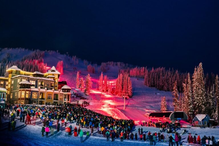
Whistler is a European-style resort, which has been recognized as one of the top five international skiing destinations, and arguably the best, in North America. In the summer months Whistler offers a bounty of activities including alpine sightseeing, mountain biking, hiking, river rafting, horseback riding and backcountry tours. Or ride a gondola chair to the top of one of the mountains for breathtaking vistas of the surrounding area.
Pemberton is about 30 minutes north of Whistler. As the Pemberton Valley opens up, so too does the number of roads leading off from Highway 99, providing quick access to hiking, climbing, and mountain biking routes that will be of interest to those seeking backcountry adventure.
Lillooet is reached along Hwy 99 from Pemberton. Like many of the towns in the Cariboo, Lillooet was born of the gold rush, and within twenty years of its founding, the town had swelled to almost 15,000 residents. Rockhounds and history buffs will find Lillooet to be a real treasure. Lillooet is also a contender for the most unusual golf course in B.C. – a local sheep farmer has converted his scenic farm into a golf course. Watch where you step!
Stop at the gold rush town of Cache Creek and visit Hat Creek Ranch, and the 1862 roadhouse that served the teams and passengers of the B.C. Express Stage Line that travelled the original Cariboo Wagon Road.
Continue your journey to Lytton, located where the green waters of the Thompson River meet the brown, silt-laden rushing waters of the mighty Fraser River. Lytton is perhaps best known as the “Rafting Capital of Canada” – numerous first-class commercial rafting companies guide visitors through the white waters of these adventurous river routes. Lytton was also on the path taken by hardy prospectors who made there way north to the gold fields. Gold rush history and native culture is evident in the different buildings and activities, such as Remembrance Day Pow Wow. Definitely a destination of unique and exciting adventures! Want a closer look at Hell’s Gate? Take the airtram for breathtaking views of the Fraser River as it roars through this famous gorge.
On your way back to Vancouver, visitors will want to spend several days exploring the lush Fraser Valley. Hope is a pretty little town with great appeal for outdoor adventures. Kawkawa Lake Park is nearby, as is Coquihalla Canyon Provincial Park. Not far away is E.C. Manning Provincial Park, with more lakes and hiking trails. The local joke here is that no matter which way you are going, the rest of B.C. is “beyond Hope”.
After a hectic day of sightseeing, relax and rejuvenate the soul at the Harrison Hot Springs. Called the “Spa of Canada”, Harrison Hot Springs is a resort town with recreation and health at the forefront.
Complete your circle tour with a stop at Chilliwack, Cultus Lake, Abbotsford, Langley and Fort Langley.
Approximate Distance: 2,000 Km
Approximate Duration: 7 to 14 days
Towns on or near this Route