 |
Information on communities shown on the map:
- Alert Bay
- Bamfield
- Campbell River
- Comox
- Cortes Island
- Courtenay
- Denman Island
- French Creek
- Gold River
- Hornby Island
- Kyuquot Sound
- Malcolm Island
- Parksville
- Port Alberni
- Port Hardy
- Port McNeill
- Powell River
- Prince George
- Quadra Island
- Qualicum Beach
- Sointula
- Tahsis
- Texada Island
- Ucluelet
- Yuquot (Friendly Cove)
Information on regions shown on the map:
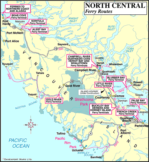
Information on ferry terminals and routes shown on the map:
- Port Hardy/Prince Rupert – Inside Passage
- Port Hardy/Bella Coola – Discovery Coast
- Port McNeill/Sointula/Alert Bay
- Campbell River/Quadra Island/Cortes Island
- Powell River/Comox/Texada Island
- Buckley Bay/Denman Island/Hornby Island
- Qualicum Beach/Lasqueti Island
- Port Alberni/Bamfield/Ucluelet
- Gold River/Nootka Sound/Yuquot/Tahsis
Other Ferry Route Maps:


