 |
Maps incorporating North Vancouver Island
Information on Towns and Regions on North Vancouver Island
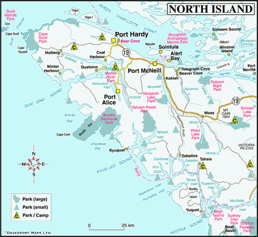
As 97 percent of the population lives on the southern half of Vancouver Island, outdoor recreationists in search of solitude come north on the island. Much of Vancouver Island once looked as the north still does today.
Thanks to recent government protection, some of the remaining wilderness, such as Brooks Peninsula, a stubby 14 km long projection on the northwest coast of the island, has been preserved. Other places, such as the most northerly tip of the island, are sheltered by the elements from the preying eye of industry.
Cape Scott Provincial Park is one of the wildest, windiest, most woebegone locales in the province for human habitation. Journeying to Brooks Peninsula or Cape Scott is only for those whose mettle has been tested by the repeated exposure to the bellows and blast-furnace of nature in the raw.
You do have to travel farther afield here in order to penetrate the cloud-laced valleys, coastal rain forest and the open ocean waters of the sounds like Nootka and Kyuquot. Some of this landscape’s mysteries lie tucked away inside the vaulted domes of underground caverns. Afloat in a sea kayak on an open sound, or deep inside the Quatsino cave system, be prepared to experience a blend of connectedness and jubilation, isolation and terror, when adventuring here. One thing is guaranteed: at the end of the day, you’ll sleep well.
Gentler conditions prevail in the sheltered waters of Johnstone Strait, where the kwakwaka’wakw First Nations are the traditional gatekeepers. To experience a tranquility that passes all description, paddle these waters where whales rub and salmon run in summer months.
Getting There
The top half of 450-km long Vancouver Island is served by a maze of logging roads, and Highway 19 (the Island Highway), which links Campbell River with Port Hardy, the southern terminus of BC Ferries’ Inside Passage and Discovery Coast ferry routes, which link Vancouver Island with the north and central coasts of British Columbia (Prince Rupert and Bella Coola respectively).
Travel to ports in Nootka Sound and neighbouring Kyuquot Sound to the north is via MV Uchuck 111, a working freighter based in Gold River that provides a year-round passenger and freight service between Gold River, Tahsis, Yuquot (Friendly Cove) and Nootka Sound.


