The Cariboo, Chilcotin and Central Coast region of British Columbia stretches from the Cariboo Mountains in the east to the west coast of BC on the Pacific Ocean. Gold prospectors have been replaced by visitors seeking guest ranches, outdoor adventure and pristine lakes, rivers and streams. Visit Clinton, 100 Mile House, Lac La Hache, Williams Lake, Quesnel, Wells, and Barkerville in the Cariboo, and Anahim Lake, Nimpo Lake, and Chilko Lake in the Chilcotin. Continue west on Highway 20 to the Central Coast and the communities of Hagensborg and Bella Coola, and the offshore communities of Bella Bella and Klemtu. The Coast region also includes the Discovery Coast, Princess Royal Island, and the magnificent Great Bear Rainforest.
Cariboo, British Columbia
Peace prevails in the Cariboo region, with rolling hills, deeply incised rivers, and many lakes providing an impressive landscape. The glow of your adventure in the great Cariboo outdoors will make you drag your feet when the time to head home draws near.
- 100 Mile House
- 108 Mile Ranch
- 70 Mile House
- Barkerville
- Bella Coola Hwy 20
- Bridge Lake
- Canim Lake
- Cariboo
- Cariboo Highway 97
- Clinton
- Fishing Highway 24
- Gold Country
- Horsefly
- Lac La Hache
- Likely
- Lillooet
- Lone Butte
- Loon Lake
- McLeese Lake
- Quesnel
- Tyee Lake
- Wells
- Williams Lake
Chilcotin, British Columbia
The Bella Coola Valley is of historical significance as a trade corridor between coastal and interior Native groups. The Chilcotin Plateau east of the Bella Coola Valley can rightfully claim to be the true bastion of the range rider in BC, with vast expanses of the Chilcotin being worked by large ranching outfits.
- Alexis Creek
- Anahim Lake
- Bella Coola Hwy 20
- Chilanko Forks & Puntzi Lake
- Chilcotin
- Chilko Lake
- Gold Bridge
Coastal British Columbia
The Central Coast will delight adventurers, with the Discovery Coast ferry service offering a circle tour through some of the province’s most beautiful terrain. Travellers can disembark, explore some territory, then reboard the ferry to another remote destination in the largely undiscovered Discovery Coast Passage.
Coastal Inlets on the Mainland Coast of BC
The remote and rugged coastline of British Columbia is indented with stunning fjord-like inlets that cut deep into the Coast Mountains of the BC mainland north of Vancouver. The inlets fall under various regions of the province, but they are grouped together here for ease of navigation, listed in order of south to north.
Cariboo, British Columbia
The Cariboo Highway is a classic 445-km ramble through the heart of the Cariboo region, with branch roads that lead west into one of British Columbia’s most thinly populated outbacks, Chilcotin country. Many towns along the Cariboo Highway are helpfully referred to by distance from Lillooet (Mile 0) north along the Gold Rush Trail. Thus 70 Mile House, for example, marks the distance between Lillooet and this point, the original site of a pioneer roadhouse. Evidence of the days of the stampeders persists in delightful places such as the roadhouses at Hat Creek, 108 Mile Ranch, and Cottonwood Creek. Even more impressive is the landscape itself, with its rolling hills, deeply incised rivers, and many lakes.
There are several approaches one can take: hurried or slow, scenic or under cover of darkness, direct or circuitous. However, no matter which route you choose when heading to or from the Cariboo, all offer rewards along the way. After experiencing the peace that prevails in this region, and inspired by sights such as that of a canoe mirrored in the surface of a crystal lake or fresh ski tracks lit by a full moon, the glow of your adventure will make you drag your feet when the time to head home draws nigh.
Chilcotin, British Columbia
Highway 20 runs for 456 km from Bella Coola to Williams Lake, linking the Central Coast with the Central Interior as it crosses the Coast Mountains and the Chilcotin Plateau, including Tweedsmuir Provincial Park and Farwell Canyon. Highway 20, also known as the Bella Coola Road, passes through diverse landscapes ranging from grassy plateaus and rolling meadows to picturesque canyons and high mountain peaks. The portion of the highway over Heckman Pass was completed only in August 1953 – by the residents of Bella Coola themselves. They gained road access to the Chilcotin Plateau and Williams Lake and a newfound freedom; hence, the route’s other nickname, the Freedom Highway.
Bella Coola (population 2,500) marks the western terminus of Alexander Mackenzie’s trek across Canada in 1793, the first crossing of the country by land. Long the home of the Nuxalk people, the Bella Coola Valley became a route to the Cariboo gold fields in 1858, the location of a Hudson’s Bay Trading Post in 1867, and a home for Norwegian colonists from Minnesota, who settled in nearby Hagensborg, in 1894. The colonists chose the area because the landscape reminded them of their homeland. Farming, lumber, and fishing industries began shortly after.
The Bella Coola Valley is of archaeological and historical significance in that it was a trade corridor between coastal and interior Native groups. The river had several villages along its length. Furs and leather were exchanged for salmon and eulachon grease, and were transported along what were called the grease trails. (You can still see, though you might not want to smell, the herring-sized eulachon being rendered into oil by the local Nuxalks at the right time of year.) Remnants of precontact Native culture include the site of Friendly Village, visited by Sir Alexander Mackenzie in 1793, pictographs near Big Rock, a burial ground and smokehouse near Stuie, and aboriginal trade trails. There are also obsidian quarries on Tsitsutl Peak.
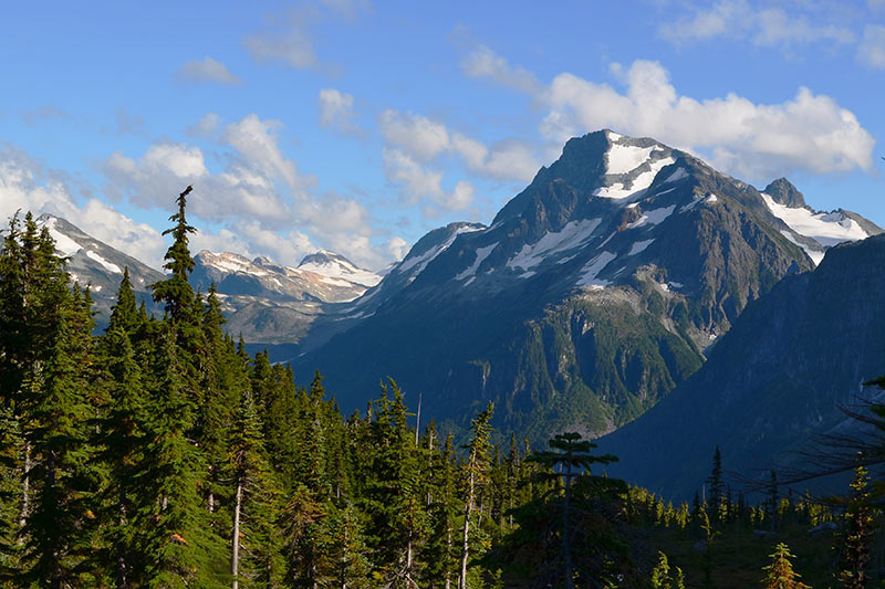
Tweedsmuir Provincial Park and Recreation Area, at over 2.2 million acres (895,000 ha) one of British Columbia’s biggest parks, is most easily accessed from Highway 20, which bisects the southern half of the park east of Bella Coola. Established in 1938 and since enlarged, it is named for the 15th Governor-General of Canada, John Buchan, Baron Tweedsmuir of Elsfield, who travelled extensively throughout the park in 1937 and was greatly impressed by its magnificence.
Roughly triangular in shape, Tweedsmuir Provincial Park is bounded on the north and northwest by the Ootsa-Whitesail Lakes Reservoir, on the west and southwest by the Coast Mountains, and on the east by the Interior Plateau. The park encompasses an astounding diversity of landscapes and conditions. Because access, facilities, and activities differ from north to south, the park is divided into two sections, with the Dean River acting as a natural boundary between the north and south. For information about the northern section of Tweedsmuir Provincial Park, see Fraser Plateau chapter.
Tweedsmuir Park South comprises many natural history features, as well as some incredibly diverse landscapes in the Coast Mountains and Interior Plateau regions. The Interior Plateau (which includes the Fraser, Chilcotin, and Nechako Plateaus), in the eastern portion of the park, is a rolling and hilly landscape. Within the park, the plateau is warped sharply upward to more than 6,560 feet (2000 m) and is largely covered with glacial drift. East of the park near Anahim Lake, the Interior Plateau abruptly gives way, at an elevation of about 4,430 feet (1350 m), to peaks of the Rainbow Range. The peaks of the Rainbow Range – Tsitsutl in the local dialect, meaning painted mountains – form an enormous dome of eroded lava and fragmented rock that presents an astonishing spectrum of reds, oranges, yellows, and lavenders. Contrasting with the vivid colouration and gentler slopes of the Rainbow Range are the higher and more rugged Coast Mountains. Vast glaciers sculpted these granite giants, leaving behind serrated peaks that are still being eroded by the alpine ice. A special feature in the upper Atnarko watershed is the magnificent Hunlen Falls, with its 853-foot (260-m) single drop over a sheer rock face. It is one of the highest waterfalls in Canada.
Four biogeoclimatic zones lie within the southern half of Tweedsmuir: alpine tundra, Engelmann spruce/subalpine fir, sub-boreal spruce, and coastal western hemlock. From the east, travellers on Highway 20 pass through the lower reaches of the Englemann spruce/subalpine fir zone in Heckman Pass (elevation 5,000 feet/1525 m) at the park’s eastern boundary, about 360 km west of Williams Lake. The road drops quickly down the Bella Coola Hill, passing through dry lodgepole pine stands on Young Creek Hill to reach the Atnarko Valley, with its fir and cedar forests.
The low-lying Atnarko and Bella Coola Valleys have a more coastal climate and vegetation. Towering specimens of coastal hemlock, western red cedar, and some remnant Douglas fir, as well as a great deal of black cottonwood on the valley floors, thrive in forests carpeted with giant sword ferns and tangles of huckleberries, blueberries, raspberries, wild roses, thimbleberries, salmonberries, wild lilies, and orchids, to name but a few of the many plant species found here.
With all those berries, it’s no wonder there are many bears. Both grizzly and black bears occupy the Atnarko and Bella Coola Valleys. In autumn they congregate along riverbanks to feast during the annual salmon spawning migrations.
Although you’ll find cowboy boots and Stetson hats to be standard issue in many parts of the province, from Surrey in the Lower Mainland to Dawson Creek in the Northeast, the Chilcotin Plateau east of the Bella Coola Valley can rightfully claim to be the true bastion of the range rider in British Columbia. Very few of the roads are paved, restricting access to only the most adventuresome and savvy map readers. Vast expanses of the Chilcotin are worked by large outfits such as the Gang Ranch, at one time the largest ranch in North America with over 1 million acres (400,000 hectares). The ranch epitomizes the spirit of this isolated region. Wherever you stop along the Bella Coola Road, there’s always a pot of (mostly free) coffee brewing.
Coastal British Columbia
There are some places, luckily, that are still inaccessible by road. British Columbia’s Central Coast is one of them. Until BC Ferries launched its Discovery Coast Passage run in the summer of 1996, the Central Coast was also largely inaccessible by water. Now, to the delight of adventurers and locals alike, from June to September the Queen of Chilliwack connects the community of Port Hardy, at the northeastern end of Vancouver Island, with Bella Coola, at the head of the North Bentinck Arm, making regular stops along the way.
For kayakers and campers, RVers and backpackers, the Discovery Coast Passage service opens up a brand-new circle tour through some of the province’s most beautiful terrain. But one of the bonuses of this trip is that you needn’t take a (four-wheeled) vehicle at all. Kayakers, backpackers, and cycle tourists can choose their destination, explore some territory, then reboard the ferry on a subsequent day. Planning your trip, which involves detailed study of the ferry schedule, is half the fun. As yet, the Discovery Coast Passage remains largely undiscovered.
This is a vast and isolated landscape of old growth coastal forests, ancient glaciers, ice fields and massive watersheds. Here you will find endless outdoor adventures and some of the world’s best saltwater fishing and wildlife viewing. You will find sheer cliffs of granite, sand dunes and peat bogs, wetlands and sea lion rookeries, rare and endangered plants and birds, salmon spawning rivers and hot springs in their natural state. No matter how you get here, when you arrive, you will certainly be inspired as this is truly a spectacular region offering adventures and experiences for all.
When European explorers arrived along this coast in the 18th century, it was inhabited by Natives from several cultural groups. Although hunters and gatherers like the tribes of the Interior, the coastal natives, due to their abundant food supply, were able to establish permanent villages. Their complex cultures were distinguished by an emphasis on wealth, a refined artistic tradition, and a rich spirit life. Travel along the coast was accomplished via cedar dugout canoes that could be impressive in their length. Although there’s nothing more inspiring than to see one of these massive canoes in action, they are only brought out for ceremonial occasions, such as a paddle trip to Vancouver or the Olympic Peninsula in Washington. These days, aluminum-hulled, high-speed boats are the vessels of choice among all inhabitants of the coast.
Explorers from Russia, Britain, France, and Spain converged on this coastline in the last quarter of the 18th century, motivated by trade possibilities or – in the case of Spain – a desire to protect territorial waters. Two British explorers, Captain James Cook in 1778-79 and Captain George Vancouver in 1792-93, did the most systematic charting of the coast. After an international tussle, the British eventually gained control of what would later become the coast of British Columbia. Colonization and settlement began in the 19th century, although British Columbia’s Central and Northern Coast is still not heavily populated. Logging, fishing, and tourism are the primary industries, though with the decline in stocks and automation in the forest, fewer people live here now than in previous decades. After a disastrous decline in Native populations (by as much as 90 percent in some nations) that began over a century ago due to infectious diseases such as smallpox and tuberculosis, today’s numbers match those of precontact times.