 |
Maps of Towns and Regions on South Vancouver Island
- Sidney
- Sooke
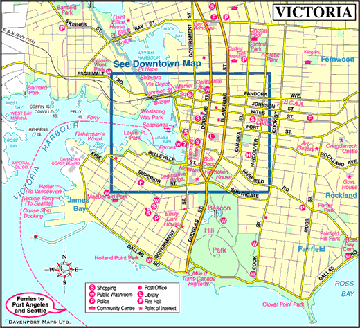
- Victoria
- Victoria Downtown
- Pacific Marine Circle Tour
- Sunshine Coast and Vancouver Island Circle Tour
Information on Towns and Regions on South Vancouver Island
The exposed waters of Vancouver Island’s southwestern coast quickly dispel any notion that an ocean is an ocean is an ocean. The true personality of the Pacific is revealed as you traverse the slopes of San Juan Ridge as the Strait of Juan de Fuca makes its entrance from the open water of the Pacific. Conditions shift dramatically from the sheltered, rain-shadowed waterways of the Strait of Georgia with its gaggle of tranquil islands. Here you face the open ocean, where nothing breaks the rolling swells or deflects the sting of winter storms. For those who listen for the force of the West Coast, here it begins to speak up, way up.
Many a dark chapter has been written about ships and crews that perished in the violent storms that rake the raw shoreline. This is the Pacific’s Davy Jones’s Locker. Thrown up on the beach, survivors considered themselves blessed if they could reach the West Coast Lifesaving Trail. As harsh today as then, less-endangered people willingly subject themselves to this legendary trail’s test of endurance. Such a reputation adds a wild spice to adventuring here. Do not treat this environment lightly. Each year some unfortunate soul ventures too close to the ocean and pays the ultimate price. Venture with care and you’ll come away with wonderful memories of your time spent by the shoreline, where many creatures live in splendid harmony with the ocean’s deep rhythms.
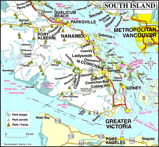
Southern Vancouver Island covers the country between Port Renfrew and Bamfield on the west coast and Malahat and Nanaimo on the east side. Most of the population lives along the east coast, where farming in the lush, rolling Cowichan and Chemainus Valleys has gone hand in hand with logging since Vancouver Island was an independent Crown Colony. The heart of agriculture lies south of Nanaimo, the Hub City, and this pastoral atmosphere persists as you make your way north to Parksville in central island. However, its hard to ignore the slopes of the Vancouver Island Mountains that begin to nudge travellers closer to the coastline for wont of wide valley bottoms. Most roads west peter out quickly in the face of this granite tour de force. The exception is the cross-island melange of paved highway and gravel logging roads that link the sheltered Cowichan Valley with the storm-battered community of Bamfield on the west coast. A greater contrast is hard to find, which is what makes exploring this region so fascinating. There’s plenty of easygoing adventuring to be found by sticking to the main routes, although everyone should treat themselves to a backroad or two where the valleys meet the Strait of Georgia. There are beaches here the likes of which are found nowhere else on the coast, with views that engender intimacy with the landscape, yet emphasize its isolation.
Getting There
Owing to the ruggedness of the southwest region, access is limited to the paved coastal Highway 14 and several unpaved backroads. Highway 14 begins in the Victoria suburb of Colwood Corners. It links the village of Sooke on the west side of Sooke Basin with Port Renfrew on the south shore of Port San Juan (actually a wide bay), a distance of 70 km to the north. To the north, the Harris Creek Mainline and Hillcrest Logging Roads link Port Renfrew with Mesachie Lake on Cowichan Lake, and from there with Highway 18 and the Cowichan Valley.
The most westerly section of the 7809 km Trans-Canada Highway runs north-south through southern Vancouver Island between Victoria and Nanaimo, a distance of 113 km. Highway 14 runs 35 km north of Nanaimo to Parksville, and beyond to the northern end of Vancouver Island. Highway 18 is a 29 km stretch of blacktop that runs east-west from Highway 1 through the Cowichan Valley between Duncan and Youbou. From Youbou a series of logging roads leads 108 km west to Bamfield on the west coast.
BC Ferries connects the Lower Mainland from Tsawwassen in Delta to Victoria on Vancouver Island <Tsawwassen Ferry TYerminal to Swartz Bay Ferry Terminal. Ferry service from the Saanich Peninsula to the north end of the Malahat Drive (Brentwood Bay to Mill Bay) connects with Highway 1. BC Ferries also connects with southern Vancouver Island at Crofton with Vesuvius Bay on Saltspring Island, and with Chemainus from Thetis Island and Penelakut Island (formerly Kuper Island).


