A short drive north of Powell River, Sliammon is the site of an ancient First Nation fishing village that has been in continuous habitation for the past two millennia. Today, the Coast Salish Sliammon Band has approximately 800 band members.
The Sliammon people travelled by water, seeking the best places to fish, hunt, pick berries or dig for roots. Some of these places were simply overnight campsites, others became locations for seasonal villages, where houses were constructed from giant red cedars.
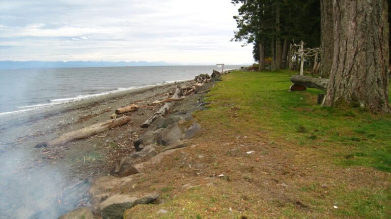
The Sliammon people have always relied on the sea for their food, with salmon being of major importance. Tidal weirs and traps were used near the mouths of spawning rivers to benefit from the ebb and flow of the tide, and harpoons, dip nets and gaff hooks were employed in the streams and rivers. An annual festivity was held to celebrate the arrival of the first spring (chinook) salmon. Today, chum salmon still forms an important part of their winter diet.
The villagers’ principal business today is the Sliammon Fish Hatchery located alongside Sliammon Creek, producing 1-1.5 million salmon annually. The hatchery is open to the public and offers cross-cultural awareness programs for school children. The best viewing time is during October and November. The actual timing of up stream migration varies slightly depending on the creek’s water level.
Miles of hiking trails in the area lead to beautiful lookouts, waterfalls, peaceful lakes, and spectacular alpine hiking. All this in an area that lays claim to the mildest climate in Canada, where the sun shines each year for an average of 1,760 hours.
Population: 677
Location: Sliammon is located on Highway 101, 6 miles (9 km) north of Powell River on the Sunshine Coast of BC, and is reached by scheduled air and bus services between Powell River and Vancouver, and by ferry from the Little River ferry terminal in Comox on Vancouver Island to Powell River. Powell River can also be reached from Vancouver in the south (5 hours, 88 miles/141 km) by catching a ferry from Horseshoe Bay to Langdale Ferry Terminal, driving from Langdale to Earls Cove on Highway 101, and catching another ferry from Earls Cove to Saltery Bay. Sliammon is 24 miles (38 km) northwest of Saltery Bay on Highway 101.
Immediately offshore from Sliammon is Harwood Island, part of Sliammon reserve land. Cultural tours to Harwood Island are available.
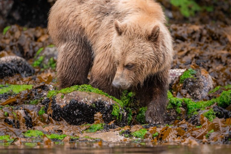
Salmon Spawn: Come fall, many of the streams that feed into Malaspina Strait teem with spawning salmon. As sure as salmon return to spawn in late summer, so too do raptors and bears follow. Although black bears in the Powell River region tend to frequent the backwoods logging roads, osprey and eagles, otters, and pine marten have no fear of approaching the coastline around Sliammon Creek in search of carrion.
Hundreds of bald eagles appear over Sliammon Creek to perch in the trees and prey on spawning salmon. Occasionally, even a black bear will put in an appearance. One particularly good viewing spot of both predator and prey is near the Sliammon Fish Hatchery, about 3 miles (5 km) north of the Powell River bridge. To reach the hatchery, follow Klahanie Road, which begins beside a Native handicrafts store of the same name on the south side of Hwy 101.
Eagle Nest: On the outskirts of the village, as you near the strait, watch for a massive, room-sized eagle’s nest in one of the trees – each year it’s enlarged and renovated to accommodate new arrivals.
Sliammon Lake: Travel by canoe to discover the Nation’s history on a safe and scenic paddle on beautiful Sliammon Lake. Enjoy the peaceful lake and coastal mountains when you travel along the shoreline, identifying various water plants used for traditional purposes. Hike into the forest to learn the traditional use of medicinal plants and trees. A refreshing swim in the clear lake and a hike on a portion of the Sunshine Coast Trail round off the tours, which are led by guide from Sliammon.
Houseboating: Take a sightseeing cruise or charter a houseboat. The Powell River and Powell Lake area is the jewel of the Sunshine Coast. Here you can cruise one of Canada’s most pristine lakes aboard a private floating resort.
Houseboating on Powell Lake.
Golf: Myrtle Point Golf Club on the shores of Malaspina Strait, five minutes south of Powell River, is surely one of Les Furber’s best design efforts. With a challenging course and spectacular views, the Par 72 layout can be stretched to over 6,900 yards. From the forward tees it comes in at just over 5,500 yards, while the white and blue tees are played at 5,900 and 6,400 yards respectively. Golf Vacations in British Columbia.
Cycling: Cyclists heading north of Powell River as Hwy 101 covers the 14 miles (23 km) to Lund will be confronted with one major hill. The highway makes a wide switchback as it climbs above the dam on Powell River. Catch your breath at the dam, from where you get a picturesque view of the boathouses on Powell Lake. Once you reach the Native community of Sliammon, the road levels out for the remainder of the journey. The wide, limestone pathway that encircles Inland Lake provides an excellent cycle route, with the gentlest of grades. You’ll enjoy it so much you might want to do it twice.
Kayaking: Other lakes well worth paddling in this extensive network include Inland Lake and newly protected Confederation Lake, which, along with Haslan Lake, comprises a complete watershed with extensive recreation values. Confederation Lake lies north of Inland Lake and can be reached by following Inland Lake Forest Road.
Canoeing & Kayaking on the Sunshine Coast.
Mountain Biking: The Upper Sunshine Coast area is well documented as having some of the best mountain biking trails in the province, most of which are clearly marked with a white mountain-bike symbol and double bands of various-coloured paints, making the routes a breeze to follow. A ride of epic proportion – the Bunster Hills Loop – is found about halfway between Powell River and Lund, north of Sliammon. It starts along Wilde Road on the north side of Hwy 101, immediately north of Sliammon, marked by orange paint and white biking symbols. The trail gains 2,460 feet (750 m) over the first 7.5 miles (12 km), but the views – and the 13.6-mile (22-km) ride down – make the effort worth it. Another extended route is the Malaspina Trail, between Powell River and Lund. One of the more scenic sections of the trail passes through Dinner Rock Forest Service Recreation Site.
Forest Service recreation sites: There are more Forest Service recreation sites concentrated around Powell River than in almost any other similar-sized area in British Columbia, which is a testament to the dozens of lakes surrounding the town. One of the best sites includes Dinner Rock, with a dozen beautifully positioned sites. The entrance to the site is on the west side of Hwy 101, 2.5 miles (4 km) south of Lund. With plenty of firewood, freshwater, and a car top boat launch, this is where you want to be when a full moon lights up Malaspina Strait and shooting stars strafe the night sky.
Hiking: The Sunshine Coast Trail stretches from the Saltery Bay ferry terminal in the south to Sarah Point in the world-famous Desolation Sound in the north. The 180-km trail rivals the West Coast Trail on Vancouver Island, offering panoramic views and wilderness campsites, while also providing access to developed campgrounds and two B&Bs for those who wish to spoil themselves after trekking through the forest.
A 2.5-mile (4-km) moderately difficult hiking trail connects the regional park at Haywire Bay on Powell Lake with the west side of Inland Lake. Along the way this up-and-down, forested route passes diminutive Lost Lake. Short lakeside hiking trails also run along the shores of Powell Lake from Mowat Bay Park and Haywire Bay Regional Park. Immediately north of Sliammon you’ll find a lengthy hiking route along the Marathon-Appleton Trail (moderate; 7.5 miles/12 km return). Some of the values of these routes include fine viewpoints at the Gibraltar and Gentle David lookouts, located off the Marathon Trail, as well as picnic sites at Rieveley’s Pond and Appleton Creek. One of the beauties of this trail system is that you can choose to do all or part of it and still find significant rewards.
Haywire Bay Regional Park is tucked into the shoreline of Powell Lake near Inland Lake, Haywire Bay is a popular recreation playground on the upper Sunshine Coast, where you’ll find picnicking, camping, canoeing and swimming. One of the treats of visiting this beach is swimming the short distance to nearby Honeymoon Island.
Okeover Arm Provincial Park, 11 km north of Sliammon, is a small campground frequented by paddlers. This park is the choice of those intent on exploring Desolation Sound. Except in the busiest summer months, you’ll probably have your pick of any of the vehicle/tent sites and adjacent walk-in sites in the forest beside Okeover Arm, a long neck of water along the east side of Malaspina Peninsula. There’s a federal dock and boat ramp here and, unlike in nearby Lund, plenty of parking, should you be heading out for an extended paddle. The park lies 3 miles (5 km) east of Hwy 101 on Malaspina Road.
To the north of Sliammon, Lund and Okeover Inlet provide a gateway to the world-famous Desolation Sound Marine Provincial Park. The pristine waters of Desolation Sound are surrounded by steep evergreen mountains, all teeming with the wildest of wildlife. One of the prime attractions of these waters is their warmth in summer months, which makes them ideal for swimming and snorkeling. The sound possesses a magical magnetism that draws boaters and paddlers from distant shores.
Of all the 32 lakes in the Powell River region, Mowat Bay Park on Powell Lake is the beach of choice. The biggest challenge is finding the park. Powell River’s road grid is such that it takes a turn or two to reach most of the recreation destinations tucked in the slopes of the Coast Mountains that rise gently from the shoreline. Mowat Bay Park is no exception, and is even a little easier to locate than some others. From Hwy 101 in downtown Powell River, follow Duncan Street east to Manson Avenue, then turn north and follow Manson to its junction with Cranberry Street. Turn east on Cranberry, then north on Mowat and follow this to the beach.
Valentine Mountain in Powell River requires just a short stair-climb to reach the top and the first of several viewpoints. It’s as if you’re standing in an observatory: as you make your way around the circumference, you see enough landmarks and reference points to bring any map to life. Islands and inlets, mountains and lakes lay spread below you. Picnic tables have been secluded in several places on Valentine’s 260m summit.
South of Sliammon is Powell River, blessed with a beautiful seaside setting and an abundance of sun, clear water and sandy beaches. Powell River is a favoured destination of families and adventure travellers seeking a wide variety of outdoor activities and recreational sites. Attractions include the National Historic District, Powell River Historic Museum and Willingdon Beach.
Circle Tours: See the best of the area on a driving Circle Tour. Head north out of Vancouver for the scenic Sunshine Coast and Vancouver Island Circle Tour. Board a B.C. Ferries vessel at Powell River that will take you across the waters of the Strait of Georgia to Comox, on Vancouver Island’s east coast. Travel south to Victoria and return to Vancouver by ferry from Swartz Bay to Tsawwassen. Circle Tours in British Columbia.